Along the 46th parallel: How the Washington constitution swung a hunting case near the Washington-Oregon border
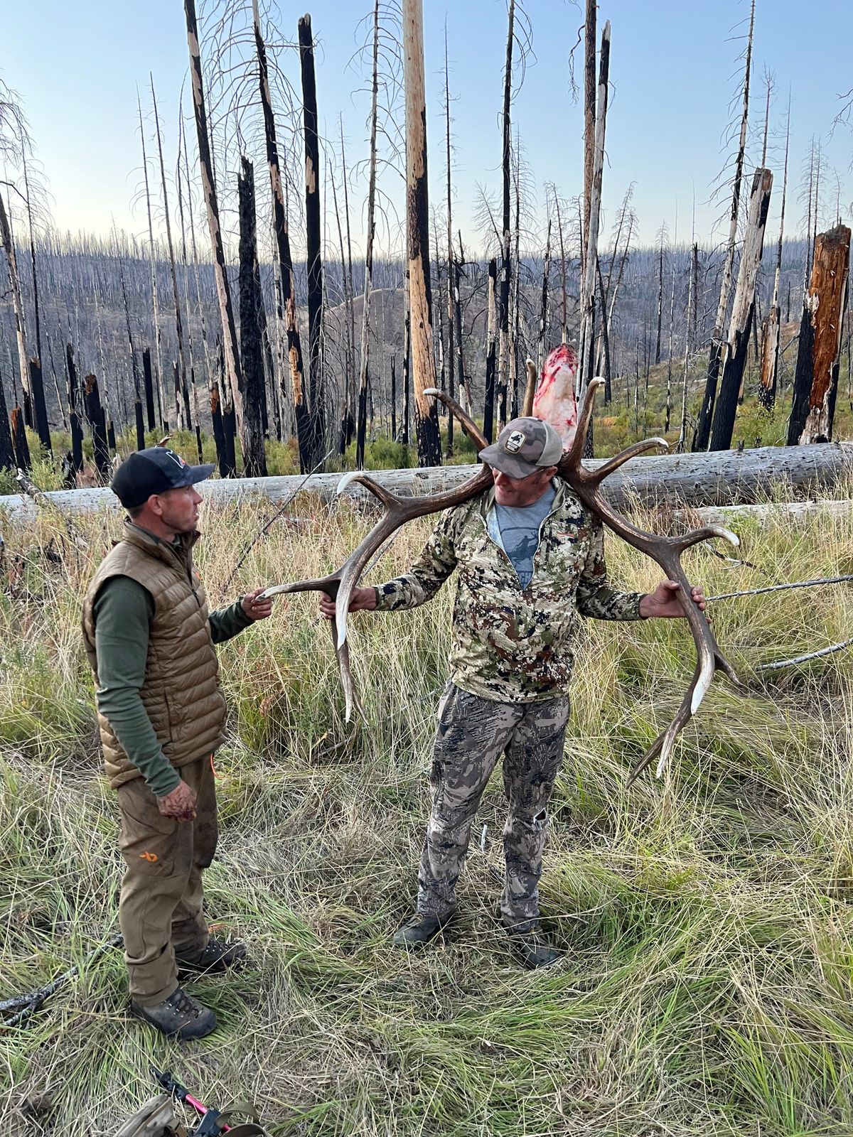

Shawn Humphrey poses with the elk he killed in the Blue Mountains in October 2022. (Courtesy of Grady Rawls)
Shawn Humphrey had always wanted to kill a big bull elk in the Wenaha unit in northeastern Oregon.
The unit on the Washington-Oregon border in the Blue Mountains offers some of the state’s most coveted elk hunting. Tags are doled out only by special drawing. For 23 years, Humphrey, who lives in Hermiston, Oregon, applied for a tag.
In 2021, he finally drew an archery tag. He and his son, Cody, hunted the area with Elgin, Oregon-based outfitter Brian Sanders that fall. Cody killed an elk, but Shawn didn’t.
The next year, he got another chance. Cody bought the Oregon governor’s tag at auction for $71,000. The tag allows the holder to hunt any part of the state with any weapon between Aug. 1 and Nov. 30. Cody bought it with his dad in mind – he wanted to give him another shot at a Wenaha elk.
They hired Sanders again. He guides a lot of auction hunts. He scouts the mountains for an animal he thinks is “worthy of the tag,” then he calls the hunters and tells them to come to the Blues.
In early October 2022, Sanders found a big bull in the Wenaha area. He called Cody, who was in San Diego at the time, and then he stayed put.
Within 12 hours, Cody and his dad were on their way to the trailhead for a long, dark horseback ride into the Wenaha-Tucannon Wilderness. The following day, they met Sanders on the east side of Fairview Canyon, a narrow gorge split by the Oregon and Washington border.
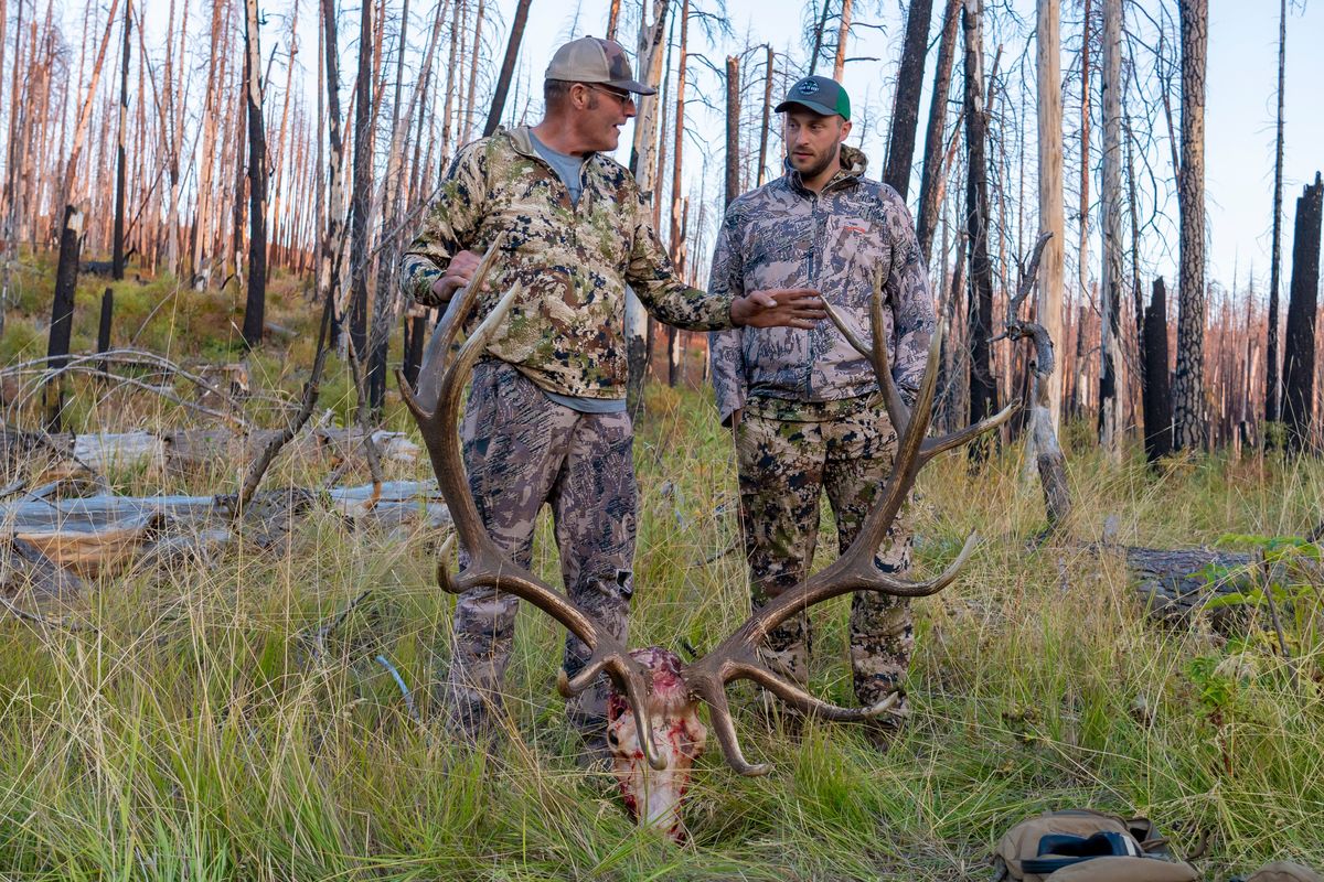
The elk was bedded down on the west side of the canyon. They waited for the right time to shoot. This time, Shawn got it done. It took three shots, but the elk went down for good. There were smiles all around.
“It was one of those things that was only going to happen once in a lifetime,” Shawn said.
It was exactly what they wanted. A video crew Cody hired was there to capture the moment. They were proud of it.
Then law enforcement officers started asking questions.
In 2023, after the video of the hunt was posted to YouTube, the Washington Department of Fish and Wildlife got an anonymous tip that the elk had been killed in Washington, which would make the hunt illegal.
WDFW police worked with wardens in Oregon and the U.S. Forest Service law enforcement officers to investigate the hunt. Court documents show they went to Fairview Canyon, found elk bones they thought belonged to the bull and pinpointed the spot where they believed the shot was taken.
When they plotted the points with onX Maps, the maps showed the locations were north of the Washington-Oregon border.
In October , the Columbia County prosecutor’s office brought charges against Sanders and Humphrey, accusing them of illegally killing a Washington elk.
But the case was dismissed in February.
The dismissal came after defense attorneys pointed out to the prosecutors the Washington state constitution’s definition of the Oregon-Washington line in that part of the state: Between the Columbia and Snake rivers, the border is on the 46th parallel of latitude.
The latitude coordinates used for the case were south of that. Investigators had said Shawn Humphrey shot from latitude coordinate 45.99928 and the elk bones were at 45.99977.
Both points are within 100 yards of the 46th parallel, but just south of it. And, per the definition in the Washington State Constitution, in Oregon.
Tim Note, a Spokane defense attorney who represented Sanders, said the state should have recognized the disconnect early in the investigation and declined to bring charges at all.
“They had those GPS coordinates long before they tried to interview anyone. They just didn’t know what the GPS coordinates meant because they relied on onX Maps rather than the Washington State Constitution,” Note said.
WDFW did not make officers involved in the investigation available for an interview. Staci Lehman, a WDFW spokesperson, said in a statement that officers “conducted a thorough investigation” using GPS mapping, multiple trips into Fairview Canyon and forensic analysis of videos and photos from the hunt.
She added that “the decision to charge and prosecute a criminal case remains within the authority of the prosecuting attorney’s office.”
Officials in the Columbia County Prosecuting Attorney’s Office maintain that the hunt took place in Washington, despite agreeing to drop the case.
Cindy Koon, a Columbia County deputy prosecutor, said they had probable cause to try the case and that mapping the coordinates show the hunt took place in Washington.
She said they agreed to dismiss because they thought they’d lose at trial.
“Ultimately, this argument about the constitution, we thought we couldn’t defeat it in front of a jury,” Koon said.
Imperfect technology
On paper, the border between southeastern Washington and northeastern Oregon looks like a straight line.
Zoom in on a screen, however, and the line changes.
It’s still mostly straight, but there are spots where it jogs slightly one way or another, breaking small distances away from the 46th parallel.
That’s not a surprise to surveyors or people who frequently work with geographic information systems (GIS) data. They know that digital maps have imperfections, and that zooming in means users are sometimes moving between datasets, which might compromise the accuracy of a specific point on the map. Pat Beehler, the state surveyor for the Washington Department of Natural Resources, said surveyors joke that GIS stands for “Get It Surveyed.”
The game warden in this case used onX Maps to plot the points where the hunt took place. OnX is a Montana-based company whose app is widely used by hunters, anglers, skiers and other outdoor recreationists.
It displays land ownership data and lets users download maps for use offline, meaning it can still work in remote places like the Wenaha-Tucannon Wilderness.
But the company acknowledges that the tool is not perfect and that there’s room for error. Its terms of service warns users that the content displayed in the app “does not constitute a legal survey.”
Molly Stoecklein, an onX spokesperson, said in an email that there are ways marking locations can go wrong, and that cellphone GPS technology is limited in its accuracy.
Phone GPS software, which trilateralizes information from satellites, is generally considered to be accurate to within 16 feet – incredibly good, but not perfect.
Stoecklein also said debating the location of GPS coordinates with three or more digits after a decimal point becomes “a game of feet and inches.” Each digit after a decimal point in a coordinate is called a decimal degree.
One full decimal degree represents 6.9 miles, meaning a latitude coordinate of 46.1 would be 6.9 miles north of 46.0. With each digit after the decimal, the distance represented shrinks. Seven decimal degrees is 1.1 centimeters.
OnX uses thousands of data sources, and Stoecklein said users should be extremely cautious around any border, whether it’s a property line or a state boundary.
“Because tech and data are inherently imperfect, and constantly changing, being transparent with our users about potential data issues is something we care about,” Stoecklein said. “Thus, onX reminds users to visually verify boundary markers and consult deeds and other official documentation, especially in edge cases like this one.”
The app’s state borders come from the U.S. Census Bureau’s Tiger/Line Shapefiles. Stoecklein said the same dataset is also used for the census, voting precincts and other government functions.
Kathy Stroud, a cartographic and government information librarian at the University of Oregon, said the boundaries provided by that dataset are useful for broad applications like gathering census information, where the difference of a few hundred feet one direction or another won’t have a major impact.
But it doesn’t provide the sort of granular detail required in this case. File descriptions that appear with the data say it shouldn’t be used to determine the legal jurisdiction of a state.
“It’s not legal precision,” Stroud said. “The legal description is the 46th parallel for that part, so that’s kind of what you’re stuck with.”
Congress first defined the legal border between Washington and Oregon more than 160 years ago. The definition in the law that granted Oregon statehood in 1859 and in the 1889 Washington State Constitution match – starting from the Pacific Ocean, the line goes up the middle of the Columbia River until near Fort Walla Walla. From there, the border was to follow the 46th parallel of latitude until it hits the Snake River.
In the 1950s, the Oregon-Washington Columbia River Compact set GPS coordinates to describe the middle of the Columbia River, attempting to prevent any border disputes prompted by changes in the course of the river.
Nothing of the sort was done for the eastern portion, however. The constitution appears to contain the most detailed description in state law for the southern borders of Walla Walla, Columbia, Garfield and Asotin counties.
Signs
Brian Sanders will tell you they were hunting close to the state line.
Fairview Canyon goes into both states, and the nearest source of water is Mud Spring, which is in Washington. On their way in, the team that was leading the Humphreys in on horseback missed a turn and rode farther into Washington than planned before Sanders went and found them.
But Sanders will also tell you that he never doubted for a moment that hunt took place in Oregon.
He’s so sure because he’s spent a lot of time in those mountains, having grown up in Elgin, a small town in the shadow of the Blues. He’s hunted in them since he was young. His business, Oregon Backcountry Outfitters, depends on knowing them well.
“I’m so familiar with that area in there,” Sanders said. “I’m in there horn hunting. I’m in there scouting. I’m in there hunting.”
Over the years, he’s seen signs screwed into trees deep that tell people where they are with a simple phrase – “Washington State Boundary,” or “State of Oregon.”
“There’s border signs,” Sanders said. “I knew we were in the right.”
After the charges were filed in early October, he hired Note to defend him. They met for the first time in November at a court appearance in Dayton, Washington. When he mentioned the signs, Note asked him to hike in to them, take pictures and plot them on a map.
He got pictures of three signs near Fairview Canyon. Each one appears to have been there since before the last wildfire ripped through the area.
One is stuck high on a standing tree, and it clearly says “Washington State Boundary.” Another is on a downed log and badly damaged, but it appears to say the word Washington. The third, although blackened by fire, says “State of Oregon.”
It’s unclear who placed them there. There are no obvious markings that credit any state or federal agency. They are on land managed by the Forest Service as part of the Umatilla National Forest. Christopher Dennis, a spokesman for the Umatilla National Forest, said the agency doesn’t post signs for state borders.
Beehler, the Washington state surveyor, didn’t have an answer either. The first survey of that portion of the state line began in 1863, when the U.S. General Land Office – now the Bureau of Land Management – hired surveyor and astronomer Daniel Major to mark the 46th parallel.
Major’s field notes indicate his crew started at the Columbia River and went east, setting “substantial” monuments along the line. At first, monuments were set every half-mile and mile. In the Blues, they scaled back because of rough terrain, putting monuments only on the “prominent ridges” for the rest of the journey to the Snake.
Beehler said those monuments would likely be wooden posts or basalt rocks marked with a “W” and an “O.” Whether they were directly on the parallel or not, Major’s crew marked a line subsequent surveyors would consider the border.
Over time, many of those monuments would likely have been replaced by steel pipes with brass caps, Beehler said. Though he didn’t know who set the signs Sanders saw, he said similar signs were “usually set later close to the actual line, not directly on it.”
The ones in the Wenaha were close. One of the Washington signs was at a latitude of 46.00012. Stroud estimated that was about 44 feet from the true 46th parallel.
Epiphany
Regardless of their origin, the signs represent the border to Sanders. In that canyon, he knew where they were. He didn’t check them on a GPS device. He took them at face value, thinking that being south of them would mean he was in Oregon.
Note was preparing to take the case to trial with that argument. He was also preparing to file a motion to exclude the onX data from the case, citing the app’s terms of service.
Then something clicked.
Note grew up in Oregon. For some reason, he remembered learning that the state fell between the 42nd and 46th parallels. He dug up the language in Washington’s constitution and saw the familiar number 46.
Columbia County’s prosecutors were arguing that coordinates starting with a 45 were in Washington. He’d been staring at the maps and coordinate numbers for months at this point, and only then did he wonder: How could that be?
“I’ve simultaneously never felt so brilliant and so stupid at the same time,” Note said.
He called the prosecutors. A few emails later, they had an agreement to drop the case. The dismissal was filed in February.
Columbia County Prosecuting Attorney Dale Slack still says they had probable cause to bring the case. They believe the hunt happened in Washington, and punching the coordinates into any digital mapping tool makes it easy to see why.
“I think the constitution says one thing, but the reality on the ground does vary a bit from that parallel,” Slack said.
Note said the logical conclusion to the county’s argument is that the constitution should be ignored. He also pointed out that the prosecutors agreed to drop the case.
“Their actions speak louder than their words,” he said.
Sanders is happy to have the case dismissed, but he fears some damage may already be done. He believes the case and rumors spreading about him guiding an illegal hunt have cost him bookings for next year. Some people have told him they thought he was out of business.
Hunting season will be here soon enough. He’s worried his calendar won’t fill up.
“There’s a monkey off my back,” he said. “But I still feel weight.”
Note said they’ll explore their options for bringing a civil suit.
The Humphreys feel like the case tarnished what was otherwise a nice father-son moment.
Cody, a former Eastern Washington University football player and partner at Priority Tax Relief, lives in Spokane. He felt good about buying the tag. The money goes toward conservation programs, and it was a way to get his dad another shot at his dream elk.
“You don’t get to do cool stuff like that very often,” Cody Humphrey said.
Investigators interviewed him but he wasn’t charged. His attorney filed a complaint with the Washington Fish and Wildlife Commission in late March over the officers’ conduct, which will be investigated by the enforcement program’s professional standards captain.
“I would like these officers to apologize,” Cody said. “It doesn’t feel good.”
Shawn Humphrey said the bull was bigger than anything else he’d killed. It was a big deal for him.
The investigation and being summoned to court almost spoiled it. He was embarrassed by it all.
He feels vindicated now. And he still has the bull.
“He looks good on my wall,” he said.